
Access & Roads
Access & Roads
How to Check Property Access and Get Coordinates for FREE
Before you make an offer on vacant land, check two things: can you actually get there, and where exactly does it sit? This guide shows you how to find GPS coordinates for any parcel and verify road access for free using your county's GIS map and Google Maps. Takes about 10 minutes. No paid tools required.

How to Check Property Access and Get Coordinates for FREE
When you find a piece of vacant land you want to buy, two of the most important questions are:
Can you actually get to it? And where exactly does it sit?
This guide shows you how to answer both questions for free, using tools that are available to anyone.
It is part of our Due Diligence series, which covers everything you should check before buying vacant land. If you missed the earlier posts, the series covers [how to find a property owner], [how to check for back taxes and liens], and [how to check land zoning] before getting here.
Why Access Matters More Than Most Buyers Realize
Access is not guaranteed on vacant land. Not even close.
Especially in rural areas, it is surprisingly common to find parcels with no legal road access at all. The property might sit behind other private parcels, with no recorded easement allowing you to cross them. That is called a landlocked parcel.
A landlocked parcel is not worthless. Some buyers specifically look for them at lower prices, knowing that access situations can improve over time as roads are added or easements are negotiated. But you should know what you are buying before you make an offer.
Andrew at Compass Land USA, who has bought and sold over 800 properties since 2017, puts it simply: "Access changes everything. A parcel with a county-maintained dirt road is a completely different investment than one you can only reach on horseback. Both can be good deals, but you have to know which one you are looking at."
Beyond access, knowing your property coordinates lets you:
- Find the parcel on a satellite map
- Verify the boundaries match what was advertised
- Share precise location information with contractors, surveyors, or photographers
- Confirm you are standing on the right piece of ground when you visit
What You Need Before You Start
You only need two pieces of information:
- The county the land is in
- The parcel number (also called APN, tax ID, or folio number)
You can find both of these on any land listing. Most legitimate sellers include the parcel number in the listing description. If a seller cannot provide the parcel number or refuses to, that is a serious red flag and a possible indicator of fraud.
You do not need any special software, paid subscriptions, or professional contacts to do this research. Everything in this guide is free.
Step 1: Find Your County's GIS Map
GIS stands for Geographic Information System. County GIS maps are digital tools that let you see parcel boundaries, ownership information, and satellite imagery overlaid on a map.
Most counties in the United States have a free online GIS parcel viewer. Some are excellent. Some are outdated and clunky. But almost all of them will give you what you need.
Here is how to find yours:
- Open Google and type: [county name] [state] GIS parcel map
- Example: "Costilla County Colorado GIS parcel map"
- Look for results from the official county website (.gov or county-specific domain)
- Click through to the parcel search or assessor map tool
You may also see results labeled "Assessor Parcel Search," "Online Parcel Viewer," or "County Mapping." These all do the same thing.
For this guide, we will use Costilla County, Colorado as our example, since it is one of the counties where Compass Land USA buys and sells land.
Step 2: Search by Parcel Number
Once you are in the county GIS tool, look for a search box. Most will let you search by:
- Parcel number / APN
- Owner name
- Address (less reliable for vacant land)
Enter the parcel number and hit Search or Enter.
The map should zoom to your parcel and highlight it. You will see the parcel boundaries drawn on the map.
If the county GIS does not have an online tool, or if the search is not working, call the County Assessor's office directly. Give them the parcel number and ask for the corner coordinates and access information. Most assessor staff are happy to help with a quick call.
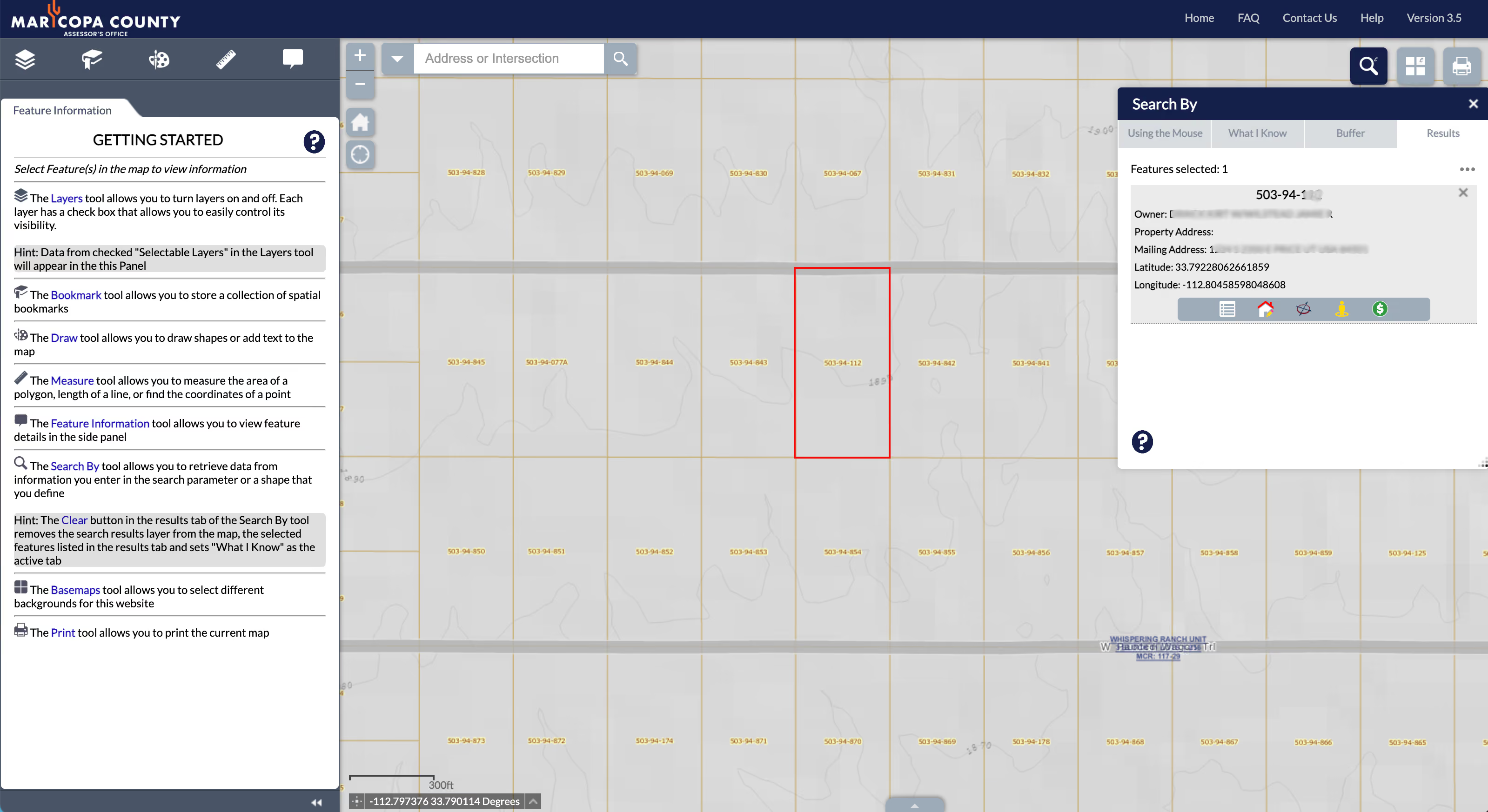
Step 3: Get the Corner Coordinates
Now that you can see your parcel on the map, you want to record its approximate corner coordinates.
Most county GIS tools have a "measure" or "coordinate" feature. It might be labeled:
- Measure
- Line Measure
- Coordinate Finder
- Click for Coordinates
Click each corner of the parcel and write down the latitude and longitude for each one.
In Costilla County's GIS, there is a "Line Measure" tool in the toolbar. Click it, then click each corner of the parcel in sequence. You will see the coordinates populate as you go.
The coordinates will look something like this:
- Lat: 37.1234° N
- Long: -105.6789° W
Note the negative sign on the longitude. That tells you the property is in the Western Hemisphere. If you accidentally drop the negative when copying into Google Maps, you will end up looking at a location in China. Always double-check.
Write down all four corners. You will use these in the next step.
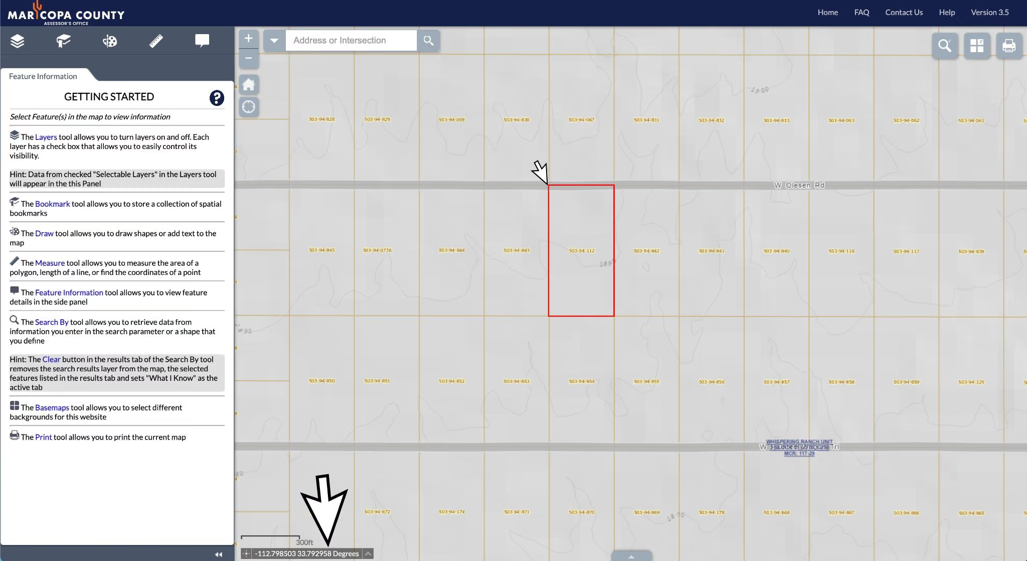
Step 4: Verify Access in the GIS Map
While you have the GIS map open, check what roads are around the parcel.
In Costilla County, and most other counties, you can toggle different layers on and off. Look for:
- Roads layer
- Satellite or aerial imagery layer
Turn on both. Zoom in on the parcel and the area around it.
What you are looking for:
- A road touching or running along the parcel boundary. This is the best case.
- A named county road nearby. County roads are typically maintained and legal access routes.
- Only unnamed tracks or trails. This may indicate informal access, not a legal easement.
- No road at all. This is a landlocked situation and requires more investigation.
Look at the properties surrounding yours. Are there homes or structures nearby? If so, there is likely road access in the area. If the surrounding parcels are all undeveloped with no visible roads for miles, access may be limited.
Step 5: Cross-Check in Google Maps
County GIS maps are great for parcel data. Google Maps is great for street-level verification.
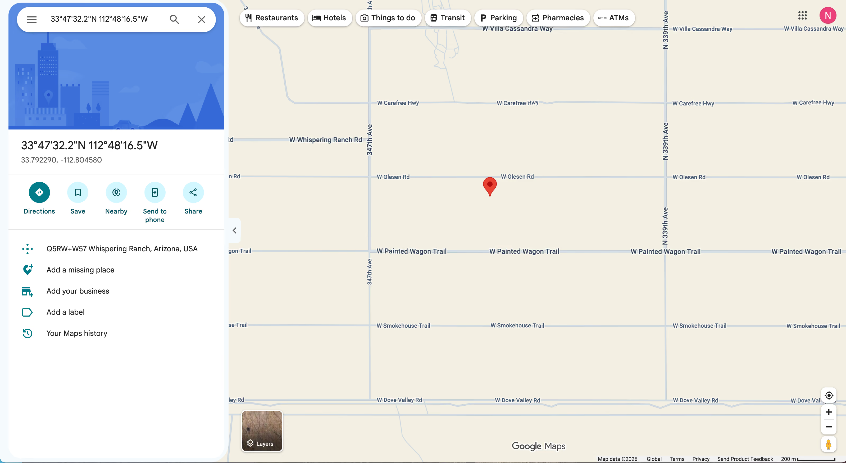
Take one of the corner coordinates you recorded and paste it into the Google Maps search bar.
Make sure you format it correctly: 37.1234, -105.6789 (latitude first, then longitude, comma-separated).
Google Maps will drop a pin at that location. From there you can:
- Zoom out to see nearby roads and landmarks
- Switch to satellite view to see road conditions from the air
- Look for Street View coverage (orange Pegman icon in the lower right corner)
If Street View is available, drag the Pegman onto the nearest road to the parcel. This gives you a ground-level view of what the road actually looks like.
In rural areas, Street View coverage is often limited. If you cannot get Street View, satellite view is your best alternative for judging road quality.
One more tip: a cheap, effective way to physically verify access is to hire a local photographer or field agent. You can often find someone on Craigslist or Facebook for $50 to $75 who will drive out to the property, take photos, and confirm whether they could get there without a problem. If they cannot reach it, they will tell you.
Step 6: Call the County If Anything Is Unclear
If the GIS map leaves you with questions, call the County.
For access questions, try the County Assessor or the County Road and Bridge Department. Tell them the parcel number and ask:
- Is this parcel accessible from a county-maintained road?
- Is there a recorded easement for access?
- What type of road is the nearest access route?
For coordinates, the County Assessor or Surveyor can confirm the boundary corners.
These calls take five to ten minutes and can save you from buying a landlocked parcel by accident.
How to Check Access for Multiple Properties at Once
If you are evaluating several properties at the same time, you can run through this process for each one. Keep a simple spreadsheet with:
- Parcel number
- County
- Corner coordinates (copy/paste from GIS)
- Access type (county road, private road, no road)
- Notes
This becomes part of your due diligence file. If you use our [land buying checklist], access verification is item four on the list, right after checking the back taxes and zoning.
When to Bring in a Professional
Free GIS tools give you a strong starting point, but they are not a substitute for a professional survey when it matters.
Consider hiring a licensed surveyor if:
- You are buying a larger parcel where boundaries are critical
- There is any dispute about where the property lines are
- The county GIS data appears to conflict with the physical markers on the ground
- You plan to build, fence, or develop the land
A boundary survey typically costs $500 to $2,500 depending on acreage and terrain. For a significant purchase, that cost is well worth it.
For title and easement questions, a local title company or real estate attorney can pull the full title chain and confirm whether a recorded access easement exists.
FAQ: Checking Property Access and Coordinates
What does landlocked property mean?
Landlocked means there is no legal route from a public road to the property. You would have to cross private land to access it, without an easement giving you the legal right to do so. Landlocked properties are legal to own but can be difficult to develop or use.
Is it worth buying landlocked property?
It depends. Landlocked properties sell at a discount and some buyers specifically look for them. If an access road is added later, or if you can negotiate an easement from a neighboring landowner, the value can increase significantly. Go in with eyes open and price accordingly.
Keep Going: What to Check Next
This is the fourth step in our Due Diligence series.
Here is the full series in order:
- [How to find out who owns a piece of land]
- [How to check for back taxes and tax liens on land]
- [How to check the zoning on vacant land]
- How to check property access and get coordinates for free (you are here)
- [How to check for utilities on vacant land]
- [How to check for flood zones and environmental issues on land]
Work through the full checklist and you will know exactly what you are buying before you put money down.
Ready to Buy Land with Confidence?
At Compass Land USA, we have done the due diligence on every property we sell. You can buy with confidence knowing access, zoning, and taxes have already been verified.
We offer flexible owner financing with no credit check and no bank required. Parcels are available in Arizona, Colorado, Florida, and Nevada.
Call or text Andrew anytime at (313) 349-0434. Visit compasslandusa.com to see what is available right now.
Andrew
Co-founder, Compass Land USA
Andrew co-founded Compass Land USA after buying and selling land for years without needing a single bank. He's been on both sides of hundreds of owner-financed deals across five states.
You've Read Enough. Time to Own Something.
Ready to Stop Renting Your Life and Start Owning Something?
Browse available land in Arizona, Colorado, Florida, Nevada, and North Carolina. Owner financing on every parcel. No bank. No credit check. Close in days.